Govt. Regd. No: 1387/068 | Tourism Licence No: 1387/068
-
Email us at
-
Call us now +977 98511 37429
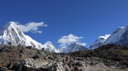
Trekking to Everest Base Camp
-
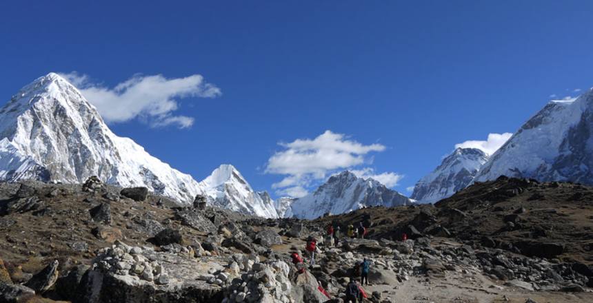 Trekking to Everest Base Camp
Ever since I studied geology at the University of Cincinnati and Penn State University, I have wanted to trek in the Himalayas and see for myself the greatest mountain range on the planet. The Himalayas are young, rugged, steep and high as a result of the collision of two continental plates (Indian subcontinent into the Asian plate).
In 2006, my step-brother Chris Alexander invited me to join him and a group of guys from his church to climb Kilimanjaro. At 19,300′, Kilimanjaro is the crown of Africa. I trained hard to prepare myself including distance running (something I had never done before) and climbing five 14ers in Colorado (peaks over 14,000′). After climbing Kilimanjaro, I immediately set my sights on Everest Base Camp.
I read books about Everest, watched movies about Everest and even got hiking guides. Every year I would ask some friends, “How about trekking to Everest Base Camp with me this year?” Some friends thought I was crazy. Others wanted to go but didn’t have the money or vacation time.
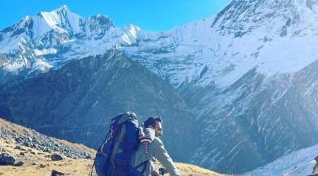
Finally in 2017, I found a hiking partner who was ready to do it–Kent Drummond. Kent and I hiked the Grand Canyon (Deer Creek Falls trail) earlier this year. He climbed Kilimanjaro in 2015. He has also climbed all 54 fourteeners in Colorado, something I am still working on. Kent is 75 years old but in great shape since he hikes 4 times a week with different clubs here in Colorado. Kent and I did a variety of warm up hikes together in Colorado including climbing several 13ers–Mt Herard, Mt Ouray, Mt Silverheels, and the trio of Kuss-Mosquito-Treasurevault.
We set a date. We bought our tickets. We made arrangements through Mount Fishtail Adventures in Kathmandu. The owner, Narayan Parajuli, is a cousin of my good friend Ruth Parajuli with whom I had traveled to Nepal twice before. My wife Ellen and I did a short 5 day trek with Narayan in 2016 to Poon Hill in Nepal.
Finally the day arrived. Ellen took Kent and
October 22, 2017
Day 0: Our first day after arriving was spent in Kathmandu resting, seeing some of the nearby tourist attractions and shopping in Thamel. We visited the Swayambhunath Monkey Temple and Durbar Square. After lunch we visited some stores in Thamel to get sleeping bags and down jackets for our trek. After resting in the hotel, we repacked what we would need for the 13 day trek and separated out the other things that we would leave in Kathmandu. In the evening, we were invited to dinner at Ramkaji Parajuli’s house which included a birthday party for his son Josef, who just turned 2.
October 23, 2017
Day 1: Day 1 was frustrating. We got to airport to catch flight to Lukla. Only 8 flights out of 24 made it to Lukla and the airport shut down because of poor visibility. There was no chance of getting an early flight the next day, so after 6 hours of waiting in a crowded airport lounge, we decided to take a helicopter for $500 each. After 3 more hours of waiting and we finally took off. It was a 40 minute flight and we landed at Lukla airport about 4:40 pm. Since we had no lunch in airport (no restaurant), and had to dump all our water to reduce weight for the helicopter, we were hungry, thirsty and tired. We stopped to have some hot soup and refill water bottles and then started hiking in the dark for 4.7 miles, 3 hours before we arrived in our teahouse lodge in Ghat. I ate Nepali Bif (beef) Momo (dumplings) for dinner which upset my stomach for the night and next day.
October 23, 2017
Day 2: I had a decent sleep in my new -20 C down sleeping bag that I bought in Kathmandu for $160. The bag says North Face and looks like North Face, but it is actually a Nepali copy. Still it was a great price considering that to buy a real North Face bag like it would cost $300+.
We hiked 7.1 miles to Namche Bazaar over very steep, rocky trail with lots of rock steps. The net elevation gain was only 1463′, but total gain with ups and downs was 4100′. But we arrived after 7 hours of hiking. We have a nice teahouse lodge for two days. Tomorrow is an acclimatization day which means we’ll be hiking higher, but coming back to Namche Bazaar to sleep. So far the weather has been overcast and cool, but with all the hiking uphill, we’re glad the sun hasn’t been beating down on us.
October 24, 2017
Day 3: I went to bed early last night 8:30 because I was tired and had a stomach ache. Imodium wasn’t handling the diarrhea, so I switched to Cipro at midnight. By morning, I was hungry. Today was an acclimatization day. We climbed a very steep trail 900′ elevation gain in 0.6 miles. The weather started out very foggy. The trail eventually leveled out at the top of the hill. As we climbed, we got teasing glimpses of the high peaks.
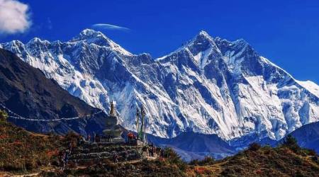
We got to a small lodge at the top and walked around it to an amazing viewpoint. Everest was peaking above the clouds, Lhotse, Taboche, and amazing views of Ama Dablam. We stopped for tea at the Everest View Hotel, and then hiked back down to Namche stopping at the Sherpa and Hillary museum. Hike lasted about 6 hours with 1400′ vertical gain. Maximum elevation was 12,738′. I’m feeling much better today.
October 25, 2017
Day 4: Namche Bazaar to Tengboche, 5 hours 50 minutes including a light lunch break, 5.5 miles travel distance, 2938′ elevation gain–which includes a lot of down and then back up.
We left Namche a 7:40 AM, climbed a 700′ hill to reach our trail to Tengboche. The trail for the next few miles was relatively flat at 12,000′ with small ups and downs, and we side-hilled about a 1000′ above the river. The peaks we saw on Day 3 were again visible. The trail then descended to cross a suspension bridge across the river at 10,800′. We stopped about 10:45 AM to rest at a restaurant and have some warm soup. After an hour rest, we started our 1850′ steep climb to Tengboche at 12650′. We arrived about 1:30 PM in a cold fog.
Tengboche is the largest Buddhist Monastery in the Kumbu area. It sits in a mountain saddle and we could see Everest above the Lhotse ridge from our bedroom window when we arrived, before the fog and clouds set in.
Hiking along the trail requires layering of clothes. At times I was hiking just with a T-shirt, much of the time with a long sleeve fleece shirt over it, and at times with gloves, warm hat, down sweater, over everything else. Air temperature is cool in the 50s but when sun gets obscured by clouds or fog it can be quite chilly.
Later today we’ll visit the Monastery. Tomorrow we’ll hike up to Dengboche at over 14,000′ and spend two nights there acclimatizing before heading up higher to EBC.
October 26, 2017
Day 5: Tengboche to Dingboche. Hike of 6.7 miles, 2651′ elevation gain, 1448′ elevation loss, 6.5 hours of hiking including a long lunch break. Our lodge at Dingboche is at 14,200′.
The weather was crystal clear in the morning with frost on the ground. The sunrise on Lhotse, Nuptse, and Everest was glorious. God was showing off his glory. The trail descended about 500′ to the river and then began climbing on the other side to our lunch spot. Generally the trail was good and not as rocky or steep as trail to Namche. I tried the Sherpa stew for lunch which was mostly like potato soup. It’s best not to eat too much for lunch because climbing with a full stomach is tough. We arrived at Dingboche about 2:30 pm.
Kent and I feel good despite the elevation. We both live at close to 9000′ and hike the 13ers and 14ers of Colorado. We are taking Diamox which is a drug used to both prevent and treat altitude sickness. No headache or stomachache. So all things considered, the trek is going very well. Thanks for your prayers.
Yesterday our guide Narayan Parajuli, who is also the owner of the Mt Fishtail Adventure trekking company, had to deal with a medical emergency and helicopter evacuation of a client on another EBC trek that had already made it to Base Camp. An Austrian lady started having severe headaches, vomiting, and was too weak to hike down. So the helicopter picked her up and flew her to the hospital in Kathmandu. We heard this morning that she is doing fine and would be released today. So this is serious business! I appreciate all your prayers for our health, safety, and success.
Tomorrow is an acclimatization day and rest day. We’ll hike and gain some elevation but come back to Dingboche before our final push.
October 27, 2017
Trekking update supplemental:
The Kumbu region that we are hiking through is the home of the Sherpa people. They have their own language. Actually, Nepal with a population of about 32 million is made up of 250 different people groups, with different customs and a variety of languages. By government statistics, 80% are Hindu, 18% are Buddhist, and the last 2% is everything else. About 40 years ago, there were almost no Christians. Today the number of Christians certainly numbers more than 1 million, and some estimate it could be as high as 3 million. My friend Shrawan Bomjan has visited at least 25 districts throughout Nepal and found churches in every one of them.
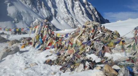
The Sherpa people are predominantly Buddhist. Before the influx of tourists trekking to Everest Base Camp, which is estimated to be 30,000 to 40,000 per year, the Buddhist Monestaries like the large one in Tengboche we’re pilgrimage destinations. The Monestaries and trails connecting them are hundreds of years old. The trails have been widened and improved, and of course tea house lodges and restaurants have popped up everywhere.
The farther one treks up into the mountains, the more expensive everything becomes since it all has to be carried in on the backs of mules, oxen, yaks, and porters. Our guide Narayan Parajuli told us that some Sherpa porters can carry as much as 100 kilograms! Wow. Our porters are limited to maximum of 25 kilograms and are actually carrying less. Our porters are young, only 17 years old.
In Tengboche, we had a chance to go inside the Monestary. I thought it would just be a quick tour, but we were invited to sit on the floor and observe one of their religious services. There was lots of chanting and burning of incense. Nothing was explained. I grew increasingly uncomfortable being in a religious service involving the worship of idols. So I said a quick silent prayer, before leaving, that the true God would reveal himself to these people, and that they would come to know Him who is the Way, the Truth, and the Life.
October 27, 2017
Day 6: Acclimatization hike from Dengboche (14,200′) to Chukhung (15,550′) and back, 7 miles round trip, 2166′ elevation gain and loss.
For second day, we woke up to frost on the ground. Even though the room is not heated, it never got cold enough for us to see our breath or to freeze water. The fake North Face sleeping bags we bought in Kathmandu have turned out to be a good purchase and have kept us warm.
The rooms are fairly basic with two single beds as the only furniture. The room in Dengboche is larger than other rooms we have had and also had several corner shelves and another shelf by the window. The mattress is comfortable and we also get a warm comforter for the bed. We also have some carpet on the floor and a dim (solar charged battery?) light bulb. The toilet down the hall has a regular western toilet and a swatty-potty. No flushing, just a bucket of water with a cup. Likewise the sink has a water jug with a spigot. Toilet paper goes into a trash bucket.
WiFi is available for a fee. It costs $5 to fully charge a cell phone or $3 for one hour of charging. Today we had our second hot shower since the start of the trek, also $5 and worth it. The water is heated by propane just before it comes out.
The hike today was fairly easy, which is what we needed to rest up before the next 3 days which will be harder and higher elevation. Tomorrow we hike to Lobuche at 16,200′. Sunday to Everest Base Camp at 17,500′, and Monday we climb Kala Patthar at 18,500′. So far we have had no headaches or any other problems. Oximeter has been 90-95% for me, with only one measurement at 88.
The weather since leaving Namche Bazaar has been clear in the mornings, cold at first but warming up quickly. In early afternoon, clouds form at elevations below us and start creeping up the valley, gradually obscuring the view and dropping the temperature as well as adding wind chill. We’re prepared with various layers, hats, gloves, etc.
I’m praying the weather stays good. I’m very aware that one turned ankle, one fall on a rock could end the whole trip. Kent gave me a scare when he tripped on a rock and fell face forward to the ground. Fortunately it was just dirt. Thanks for all you prayers and encouraging responses to these updates. They all help immensely!!!
October 28, 2017
Day 7: from Dengboche (14,200′) to Lobuche (16,200′). Trip was 5.6 miles, 2611′ elevation gain including ups and downs, 5.5 hours.
The trail started with a fairly steep climb of 30 minutes and the leveled off to a gentle side-hill climb. It was definitely colder than other days as the wind began to pick up. Of course we have been hiking above tree-line for the past 2.5 days so there is nothing to block the wind. The trail which had been trending ENE now turned north up a different valley to offer us views we had not seen before.
After hiking for about 3 hours, we arrived at a restaurant/rest stop called Thukla at about 15,143′. Even though this was supposed to be our lunch spot, we chose to eat some trail snack and have a hot drink, instead of eating a big lunch. Right after our break, we did a steep climb to Thukla Pass at about 15900′. There were great views and a bunch of memorials set up, including one to Scott Fisher, the American climber and guide who climbed Everest 8 times but died in 1996 along with about 14 other climbers in one of the worse tragedies on Everest. You can read the story in Jan Krakauer’s book, “Into Thin Air”. After hiking for less than an hour from the pass, we rounded a corner and got an amazing sight of the valley ahead—Pumori, Nuptse and other peaks that form the Nepal-Tibet border. Of course, Everest itself remained hidden by other peaks. But it was amazing.
Everyone is still doing amazingly well. Ramkaji developed a headache so Narayan gave him some Diamox and I gave him some Advil along with a short lecture on symptoms and dangers of HACE and HAPE. If we see those symptoms, then we must descend immediately to lower elevations.
Thanks for all who are following our trek, posting encouraging notes, and praying for us. You have no idea how much it means to me!
Tomorrow we continue hiking up the valley to Everest Base Camp at 17,594′. It will be a long tiring day. We don’t move very fast at these elevations. Tomorrow night we’ll be at Gorak Shep, our highest tea house at 16,961′. Blessings to all.
October 29, 2017
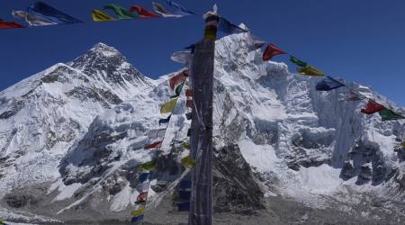
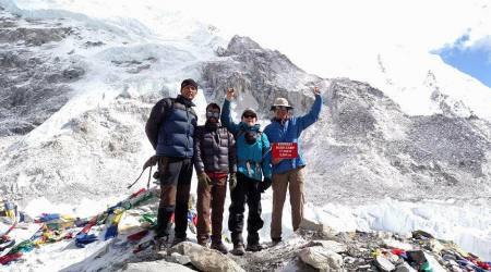
Day 8: it snowed a little last night. So after we arrived in Lobuche, it got very cloudy. Everything is charged by solar panel. So I couldn’t charge my InReach tracker. Arrived in Gorak Shep about 10:30 AM and leaving my InReach to charge during the day. Meanwhile we will continue hiking 3 more hours to EBC and then back to Gorak Shep. Hopefully my InReach will charge up for the rest of the trip.
Everything is going well considering we are hiking above 17,000′. We made it to EBC about 1:35 pm. It was sunny, but windy and cold. And the ground was very rocky. We didn’t see any climbing parties. The Khumbu glacier looked like it had shrunk in recent times judging by the size of the lateral moraines that we we’re hiking on. The towering ice seracs that the climbers have to navigate to cross the glacier and climb the icefall looked dangerous.
We made it back to Gorak Shep about 3:45 PM about 30 minutes after the sun went behind the clouds and temperature dropped.
Tonight we go to bed even earlier than our usual 8 PM. Tomorrow we get up at 4 AM to climb Kala Patthar for view of the summit of Everest. Then back to Gorak Shep for breakfast and begin long trek back to Lukla.
October 30, 2017
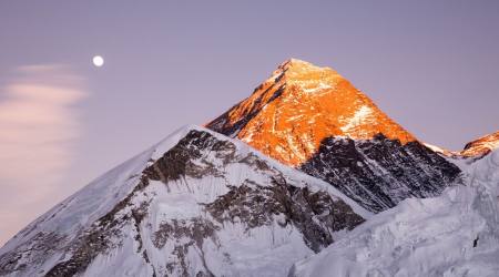
Day 9: Gorak Shep (16,900′) to Kala Patthar (18,578′), back to Gorak Shep and passing through Lobuche to Thukla (15,100′). Total distance was 8.3 miles, 2500′ elevation gain, and 4400′ elevation loss. We hiked for 9.5 hours.
We got up at 4 AM and started hiking Kala Patthar at 4:30 AM. Kala Patthar means “black rock”. Close up the rock was actually a light colored igneous rock, but it was coated with black lichen. It took us 4 hours to climb to the top and return to Gorak Shep. I was very warmly dressed in a down parka and ski pants, glove liners and ski mittens. Still my hands and feet were cold. My water bottle partially froze.
It was so cold on top that I just took some pictures with my camera and phone, and then started down. I was only carrying a water bottle and camera, no back pack.
The sun came up as we were hiking providing ever changing displays. Back at our tea house, we ate breakfast and packed up our duffels.
We made it to Lobuche by 1 PM. I was feeling exhausted from not sleeping well and from two long hikes at high elevation. We ate some lunch and rested and then continued hiking for another hour and a half to Thokla. We were still two hours away from our planned stop for the evening in Periche. But weather was getting colder and windier so we stopped in Thokla for the night.
I’m hoping for a good night sleep. The last few nights at high elevation have been a struggle for me to sleep. Something about seeing your breathe in the room and bundling under a down bag and then putting on a heavy comforter, wearing warm clothes in the sleeping bag. I’m so looking forward to my own house, a hot shower, my own bed…
Tomorrow we continue to descend in elevation heading back to Lukla at a quicker pace than the trek to base camp.
October 31, 2017
Day 10: Thokla (15,100′) to Periche (14,000′) to Sumare for lunch, to Tengboche (12,800′) to Phunki Thenga (10,900′) by the river for the night. Hiking for 9 hours and 20 minutes for 10.5 miles. We gained 1773′ and lost 5600′. It was a long day but thankfully most of it was downhill.
I did sleep better last night but seemed to have developed a cold. Stuffy runny nose means breathing through my mouth which makes my throat dry and sore. Lots of people here have some variation on cough or running nose. It is very difficult to maintain any semblance of sanitation when there is no running water, no sink, and primitive toilets. The ladies in my life would not like it!
As we get closer to Namche Bazaar, conditions improve. We are one day from Namche and 3 days from the end of the trek. This update will be delayed since no internet in our tea house tonight.
November 1, 2017
Day 11: Phunki Thenga to Namche Bazaar to Monjo. Distance was 8.1 miles with 2200′ elevation gain and 3570′ elevation loss. Trip time was 7.5 hours.
If you are not a long distance backpacker, which Kent and I are not, it’s really difficult to imagine getting up and hiking through rugged mountainous terrain with high altitude for 13 days, and not having a day to rest up. We did have two acclimatization days, but they were not REST days. We we’re hiking higher on those days but coming back to the same camp and same elevation. Sometimes Kent and I look at each other and say: “What were we thinking?”
Kent is a great hiking partner. He’s 75 years old, but strong and fit from hiking four days a week in Colorado. He’s very experienced, having taught Outward Bound adventures when he was younger, working ski patrol for Arapahoe Basin ski area where his dad was on the board. We actually met a couple of Swedish men who are 70 and 68 years old that did the same trek as we did. We also met a 78 year old man who was hiking to Tengboche Monestary. Other than a few exceptions, most trekkers are much younger, probably in their 20s to 40s. We do see the occasional overweight or out of shape person, and we wonder if they will make it.
It does take perseverance, and the trekkers on the trail seem to have lots of that! We have heard so many different languages and met people from so many countries. It’s a great cultural experience.
We ate lunch in Namche Bazaar and Kent and I both had a chicken burger with fries and soft drinks. It was such a pleasant change from noodles, rice, and ramen soup. This afternoon we had our first “hot” shower (solar) since Dengboche 5 days ago. It felt really good.
Even though we were back-tracking the same route we came in on, the weather was better and we could see more mountains that we’re obscured by clouds and fog on the way in.
Tomorrow we have a 5 hour hike to Lukla, followed by an early morning flight back to Kathmandu. We’re looking forward to our return to civilization!
November 2, 2017
Day 12: Our final day of trekking from Monjo to Lukla. Trekking distance of 7.7 miles, 5.5 hours, 2710′ elevation gain, and 2137′ elevation loss. We left Monjo about 8 AM and arrived in Lukla by 1:30 PM without stopping for lunch. We were hoping to catch an afternoon flight since the weather was clear, but planes were full. We are scheduled to fly out early tomorrow if the weather is clear.
The Lukla airport was built in the mid-1960s. Edmund Hillary purchased land from locals for the airport. The runway is only 527 meters long with an 11.7% pitch. The planes actually land uphill. There is a steep mountainside at the end of the air strip so there is no room for error. This airport was only paved for the first time in 2001. The Lukla airport has been rated the most dangerous airport in the world for the past 20 years owing to it mountainside perch and other characteristics mentioned above.
We had time to watch several planes land and takeoff. There is only room for about 4 planes to park plus about 3 helicopters. Takeoff and landing are based on Visual Flight Rules. The problem is that at 9350′ elevation, it is frequently cloudy or foggy causing all flights to be cancelled. That’s why we had to take a helicopter to get here from Kathmandu.
We’re hoping for clear weather in the morning. Kent and I want to experience taking off going downhill and off the edge of a cliff. Quite a thrill ride!!
After 12 days of trekking, we’re ready for some rest days, doing some laundry at Ramkaji’s house. The plan is to go to Lamosangu for a couple of days before Kent leaves so he can see the villages, Ruth’s parent’s house, and see how Nepalis live outside the cities. I’m looking forward to seeing Bha and Ama, Ruth’s parents.
November 3, 2017
Day 13: End of trekking and return flight from Lukla to Kathmandu. We got to the airport at 7 AM. The weather was clear. There were supposed to be 3 planes flying back and forth for our airline (Sita), but one was grounded for technical reasons. Ugh! So we waited and waited. Finally after 2 hours we got a boarding pass and after another hour we finally boarded.
The airport, when it is open, is very busy. Some planes land, deplane passengers, board new passengers without shutting off the engines, and take off 5 minutes later.
The takeoff was exhilarating. We were actually airborne before reaching the end of the short runway. The mountain simply falls away for several thousand feet at the end of the runway. The ride was a bit bumpy but the views were great.
It felt good to be back in civilization. Ramkaji took us out to Kathmandu Coffee House where I had a delicious salad, french fries, and a chocolate Oreo milkshake. Yum! After a shave, hot shower, and doing a load of laundry, we felt human again.
Tomorrow we take Kent out to Lamosangu to see the Parajuli home and farm and visit Bha and Ama. I’m looking forward to the reunion!
November 3, 1017
Trekking Summary:
12 days trekking for a total of 82 hours
82 miles (132 kilometers) walked
27,066 feet (8250 meters) of elevation gained
237,096 steps walked per my Fitbit (19,758 avg per day)
Casualties: 1) our trekking guide Narayan Parajuli had to replace his hiking boots when sole of one boot came off; 2) Kent and I each tripped once (no injuries); 3) Kent and I each developed a “Khumbu cough”, high altitude bronchitis accompanied by stuffy sinuses and a runny nose. It took about 3 weeks to get over it!
I took approximately 1000 pictures mostly with my Sony A6000 camera. Ramkaji probably took even more with his phone and Nikon camera.
November 4, 2017
Reflections on trekking to Everest Base Camp and lessons for life:
As I think about completing this 2 week journey, that for me has been a dream for the last 11 years, since climbing Kilimanjaro in 2006, it seems that an analogy can be made between a trek like this and our journey through life. So if you permit me to wax philosophical for a few minutes, here are some of my reflections:
- Don’t give up your dreams or let them die from inactivity; pursue them until they become a reality.
- Set a goal; have a destination; make a plan.
- It’s important to have an experienced guide, someone who has taken the journey before and knows the way.
- Take some friends with you. You will need to help and encourage each other. (This was the hardest thing in planning to go to EBC was finding a friend with same goal and commitment).
- It important to have a support network back home. I can’t tell you how much your Facebook comments, words of encouragement, Bible verses, and prayers did to lift my spirits as we faced each day.
- Be prepared for the unexpected and the unexpected won’t happen. We saw many people hiking with lighter packs, light weight trail shoes, less water, etc. But we were ready for all kinds of weather and conditions and glad we were. I don’t know the success rate on a trek of this kind, but we saw many people that we figured we’re not really adequately prepared for what lay ahead.
- Don’t carry too much…leave the luggage behind. Going without things we think are essential makes you appreciate them all the more when you get back.
- One step at a time, one milestone at a time, one day at a time. God gives us the strength we need bit by bit as we rely on Him.
- Nothing worthwhile in life is achieved without perseverance. Keep at it. Never, never give up!
By Larry Karasevich
Email: [email protected]
Other Categories
Most view
-
Everest Base Camp: Challenge yet opportunity
Category: Trekking -
Trekking to Everest Base Camp
Category: Trekking -
13 Days Everest Base Camp Trekking Update
Category: Trekking -
Around Manaslu Trekking – Offer Incredible Views Of Manaslu Ranges
Category: Trekking -
16 Best Trekking for 2024
Category: Trekking -
Mardi Himal VS Annapurna Base camp Trek
Category: Trekking -
Trek to Everest
Category: Trekking